Today, we will drive through Custer State Park and head toward Spearfish, SD and to Devils Tower. From there, it's back on I-94 to Sheridan, Wyoming where we will spend the weekend with our friends Terri and Rick.
The day would be full of wildlife and beautiful sites. Within a few miles, we had to slow down to avoid this flock of turkeys that were crossing the road, then a couple of deer watched us drive by and these two buffalo were feeding next to the road. Not a bad start to our drive.
We continued north on the Needles Hwy. For flat-landers from the Midwest, the views are amazing.
There is a sign at the entrance to Needles Hwy warning would-be travelers about tunnels—very small and narrow tunnels, blasted out of the solid granite rock...tunnels that your poor vehicle could end up getting wedged into if too large, and yes, it happens a few times every camping season. The sign listed their sizes: 10’ high by 10’ wide, 9’ x 12’, 8’ x 12’, etc.
Carolyn pulled the side mirror in for this one below. It's probably a good thing that she did. There isn't a lot of room to spare.
This is the rock formation that gives the highway it's name. You can see the needle's eye when you emerge from the tunnel in the previous picture.
We left Custer State Park behind and headed toward Spearfish, SD. Along the way, we found a great place to pull over for a quick sandwich for lunch. My job required lots of travel and, for many years, I was always in a hurry to get somewhere. I can honestly say this idea of slowing down to have lunch in a place like this is a pretty foreign idea, but I'm trying to learn...
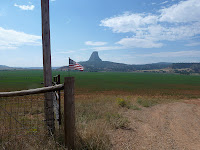
Shortly after our lunch stop, we passed into Wyoming and soon got our first hazy glimpse of Devils Tower. I like this photo with the small American flag on the fence post. This seemed to be a fairly common way for ranchers to display flags...a nice touch in a wide open part of the country.
The area around Devils Tower is flat so it can be seen from miles away. It rises 1,267 feet over low hills. It's one of the distinctive natural landmarks that we see in pictures of the western U.S.
Devils Tower was named in 1875 when the interpreter for Colonel Richard Irving Dodge's expedition translated the native name as "Bad God's Tower."
The formation of Devils Tower is a mystery and is debated by geologists. Most consider the tower to be an intrusion of molten rock that pushed into surrounding sedimentary rocks before solidifying, while others call it a volcanic plug or the remnant of a volcano's neck. No evidence in the area indicates that any volcanic activity took place here, but one theory is Devil's Tower is an intrusive body formed by magma which cooled underground and was later exposed by erosion.
Climbers are allowed but Devils Tower is a National Park so there are rules that must be followed. If you have the urge, just google "climbing Devils Tower". When you get to the part about the dangers, maybe you'll likely change your mind and simply walk around the trails like we did. The trail is about a mile long and goes completely around Devils Tower.
This is a structure we saw as we left Devils Tower. Our D-I-L, Ashley, was a biology major at BGSU and likes her "critters". She will recognize it as a lizzard.
What a wonderful and interesting stop. We are off toward I-94 and Sheridan, WY which is about 160 miles away. It's been a good day.


No comments:
Post a Comment