Tuesday, September 4, 2012

Day 11 - Little Bighorn Battlefield

After three great days with Terri and Rick, we headed north. We wanted to visit the Little Bighorn Battlefield then continue to Red Lodge, Montana.
The north plains are rolling grass-lands.  Trees??? What trees???  This area has very few.  It's wide open prairie country that supports grazing animals like cattle and pronghorns. 


The Little Bighorn Battlefield National Monument was a nice stop on our agenda.  We spent a couple hours at the visitor center and touring the grounds. Unless you are totally familiar with the Battle of the Little Bighorn, I would suggest starting your visit by watching the video in the visitor center.  It gives a great overview of the battle which is much more than "Custer's last stand" that we associate with and always hear about.

This is the only national monument where we saw this cell phone self-guided tour.  Dial the number and select the stop.  Give it a try right now.  It's a great service that would be a nice addition at other monuments.
This is the hill where General Custer made his final stand.  Markers show where each soldier fell.  General Custer is in the center.  His marker has a black face.
There were 268 soldiers killed during the battle.  A little over 100 were near Custer - the others were scattered over a fairly large area.  This picture shows an area almost a half mile away from the area in the pictue above where General Custer fell.


There is a fairly new memorial for the native Americans or Indians whichever your preference.  The panels on the inside provide information for each of the tribes who participated in the battle.
Did you know there is a national cemetery at the Little Bighorn?  The Custer National Cemetery is the final resting place for many of our nation's veterans and their families.  The cemetery is closed for internments except for direct relatives of those already buried there.

Our visit lasted longer than we planned but the history was compelling.  If you are in the area, I recommend stopping.

Day 10 - Labor Day weekend with Terri and Rick

Carolyn and Terri became friends in grade school in Michigan. Terri spends her summers in Sheridan, Wyoming where her husband (Rick) works year around.  Rick is an avid hunter and outdoors man, so Wyoming seems like the perfect place for him.  Of course, their other option is Michigan, which isn't a bad choice either, where Terri winters to be near family and to avoid the harsh winter snows of WY.   

Rick and I were planning to do some shooting in the Wyoming countryside but it was looking like we would have to put it on hold until our next trip to Sheridan due to Rick's recent knee replacement surgery.

But we got up on Saturday morning and Rick was ready to give it a try so we drove to a favorite location just a few miles from town. We were able to get off a few shots and see some great Wyoming countryside.  Kudos to Rick for heading out on the range with a painful knee.


On Sunday, Terri and Rick took us for a ride on the Bighorn Mountains Scenic Byway.  Again, Rick was game to go even though he knew his knee would not make it an easy day.  We had no idea what a great day was ahead of us but, holy cow, I could post dozens of photos here. 


After driving through the small town of Dayton, we started up the mountain.  The sights started to get better and better.  It was like driving thought the Needles Hwy in Custer State Park.  There was an overlook near the top of the first mountain range. We pulled in and found a group of a dozen or so hang gliders.  Of course, I grabbed my still and video cameras and jumped right in the middle of everything and watched several launches.  That has to be one heck of an adrenalin rush!!!  Here is video of a couple launches.


For as interesting as the hang gliding was, we had lots more to see and off we went. 

The first stop was Shell Falls.  Shell Falls is like a mini Grand Canyon.  You can only imagine the rush of water over the falls during the spring snow melt.


Carolyn and Terri


This is "special" country. It's a good thing we have digital cameras or we would be spending a ton of money on film and processing. Every turn of the road seems to bring a better view than the one before.  


Pretty cool country isn't it?  It's not very good for growing corn and soybeans but it fits grazing cattle quite well. Next on the list was a stop for lunch at Dirty Annie's. At first glance it seemed like a tourist trap, but it turned out to be full of locals who were enjoying their lunch. 


The burgers and milk shakes were great.

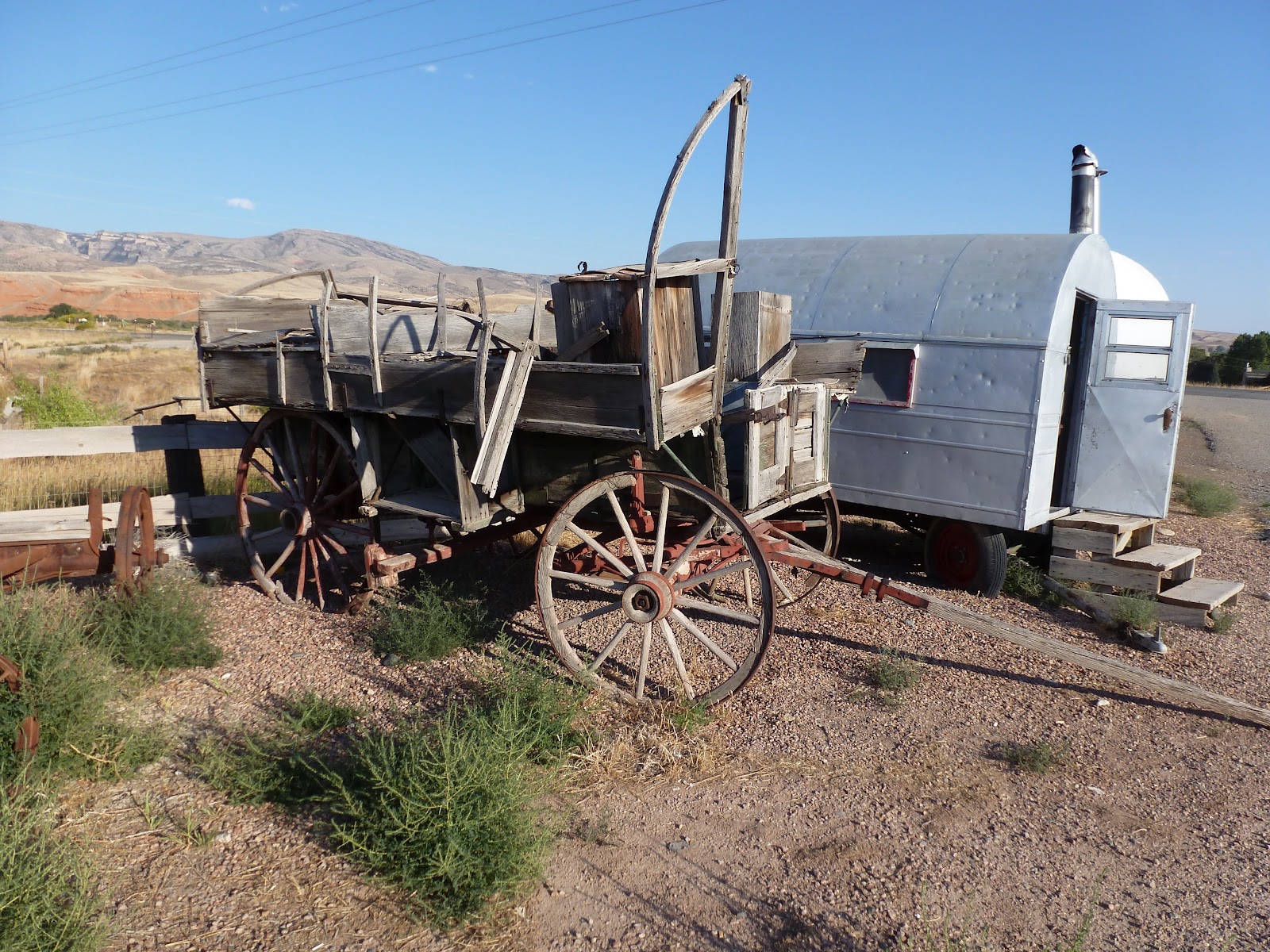
Remains of a covered wagon and sheep herders wagons were on the edge of the parking lot.  The covered wagon looked like an original to me.  Click to enlarge the pictures and look at the details.  There are ribs for the canvas top still visible. 

The sheep herders wagons have been updated with rubber tires but the interiors were equipped with wood stoves so they might have been originally used by shepards in the 1800's to follow the herds in the area. These sheep herders wagons are still manufactured today but are mostly used as RV's for short trips.


The next stop was to view the dinosaur prints at Red Gulch Dinosaur Tracksite which is just a short drive from Dirty Annie's.


Paleontologists believe the prints left at this tracksite were formed in the Middle Jurassic Period, somewhere between 160 and 180 million years ago. The prints were made in the Sundance Formation of rock, an ancient seabed (covered by the Sundance Sea). The dinosaur walked through slimy mud that was coated by algae. The algae helped hold the tracks together while the mud dried out and started to turn into limestone. Over time, the tracks filled with more dirt and mud, then it was all washed away, leaving the tracks behind. Scientists do not know what kind of dinosaur made the tracks.

The area pictured below is known as the "dance floor" since there are lots of tracks from a lot of critters. The area is probably 100 feet wide by 200 feet long...about the size of many city home lots.  When you first step onto the dance floor it is difficult to see the footprints.  Soon you discover the first one, then two, then three, then a pattern of footprints of a dinosaur that walked across the dance floor. 
Here's one

The steps are this far apart

See the steps?

This was another fun stop, but it's mid afternoon and we have to think about heading back to Sheridan. The choice was to go south and east or backtrack to see if we could find elk and moose.  It didn't take long to decide to go hunting for critters.  Actually, Terri was pretty intense about finding me a moose and she didn't disappoint. 

We were just west of Burgess Jct. when we saw cars on the edge of the road.  What folks were watching turned out to be a big bull moose laying close enough to the road to get some good pictures. We watched for awhile, but it was getting dark so we headed toward home.  Then, only a couple miles down the road, we saw two young moose. We stopped to get a couple quick pics then continued, but again, we saw brake lights. This time it was another big bull. Even though it was dusk, I jumped out of the car and took some video.  Terri's guide service turned out to be pretty darned good.

  
By the time we got back on the road it was almost dark. Over the next 40 or 50 miles everyone was on the lookout for deer and antelope that might decide to cross the road. We did see several but, fortunately, we didn't hit any of them.


Saturday, September 1, 2012

Day 8 - Custer State Park to Wyoming

This is a long post. I'm sure there are blogging rules about length of posts, but I'll just claim ignorance as a newbie and continue like I don't know any better...

Today, we will drive through Custer State Park and head toward Spearfish, SD and to Devils Tower.  From there, it's back on I-94 to Sheridan, Wyoming where we will spend the weekend with our friends Terri and Rick.


The day would be full of wildlife and beautiful sites. Within a few miles, we had to slow down to avoid this flock of turkeys that were crossing the road, then a couple of deer watched us drive by and these two buffalo were feeding next to the road.  Not a bad start to our drive.


We continued north on the Needles Hwy.  For flat-landers from the Midwest, the views are amazing.


There is a sign at the entrance to Needles Hwy warning would-be travelers about tunnels—very small and narrow tunnels, blasted out of the solid granite rock...tunnels that your poor vehicle could end up getting wedged into if too large, and yes, it happens a few times every camping season.  The sign listed their sizes: 10’ high by 10’ wide, 9’ x 12’, 8’ x 12’, etc.


   Carolyn pulled the side mirror in for this one below. It's probably a good thing that she did. There isn't a lot of room to spare.


This is the rock formation that gives the highway it's name.  You can see the needle's eye when you emerge from the tunnel in the previous picture.


We left Custer State Park behind and headed toward Spearfish, SD.  Along the way, we found a great place to pull over for a quick sandwich for lunch.  My job required lots of travel and, for many years, I was always in a hurry to get somewhere.  I can honestly say this idea of slowing down to have lunch in a place like this is a pretty foreign idea, but I'm trying to learn...

Shortly after our lunch stop, we passed into Wyoming and soon got our first hazy glimpse of Devils Tower.  I like this photo with the small American flag on the fence post.  This seemed to be a fairly common way for ranchers to display flags...a nice touch in a wide open part of the country.


The area around Devils Tower is flat so it can be seen from miles away.  It rises 1,267 feet over low hills.  It's one of the distinctive natural landmarks that we see in pictures of the western U.S.
Devils Tower was named in 1875 when the interpreter for Colonel Richard Irving Dodge's expedition translated the native name as "Bad God's Tower."

The formation of Devils Tower is a mystery and is debated by geologists. Most consider the tower to be an intrusion of molten rock that pushed into surrounding sedimentary rocks before solidifying, while others call it a volcanic plug or the remnant of a volcano's neck. No evidence in the area indicates that any volcanic activity took place here, but one theory is Devil's Tower is an intrusive body formed by magma which cooled underground and was later exposed by erosion.


Climbers are allowed but Devils Tower is a National Park so there are rules that must be followed.  If you have the urge, just google "climbing Devils Tower".  When you get to the part about the dangers, maybe you'll likely change your mind and simply walk around the trails like we did. The trail is about a mile long and goes completely around Devils Tower.


This is a structure we saw as we left Devils Tower. Our D-I-L, Ashley, was a biology major at BGSU and likes her "critters". She will recognize it as a lizzard.


What a wonderful and interesting stop.  We are off toward I-94 and Sheridan, WY which is about 160 miles away. It's been a good day.